 I want to introduce you to Mark Balwanz. He is one of my students who approached me to see if he could do an independent study with me that related to web mapping. How could I say no? I gave Mark some materials to work through so that he would know how to stand up his own server (using node.js), and then gave him materials related to Arcserver (the ESRI online courses), and some instructional material on Geoserver. At the end of the class I asked him to create the same exact mapping web site using both Arcserver with Openlayers as a front end and also Geoserver with Openlayers as a front end. I then asked him to write about his experiences. So, over the next four Fridays, Mark will introduce you to his successes and frustrations in learning how to create a mapping web server in only a semester.
Also, notice the title says Arcserver AND Geoserver, not Arcserver VS. Geoserver!! This isn’t a competition or a benchmark. It is one student’s experience in standing up identical web applications for the first time, using both platforms.
To whet your appetite, here are two screenshots of both applications – notice how similar they look:
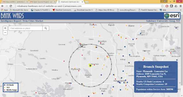
Result of Mark’s website using Arcserver on Amazon AWS
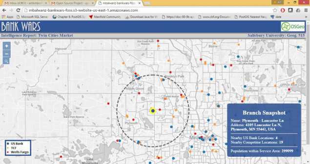
Result of Mark’s webserver using Geoserver running on Amazon AWS
The Web Duel
Mark Balwanz
Introduction
Web GIS is a topic that everyone in the industry is constantly thinking about and with good reason, serving GIS data and analysis tools out on the web exposes the power of GIS to a much wider audience and leads to greater adoption within organizations. The problem that most GIS professionals have is that there are an almost endless list of options for creating and serving GIS on the web.
For instance, ESRI customers have the ArcGIS Online offerings along with the option to build their own applications using the ArcGIS API for JavaScript and ArcGIS for Server. The open source side of the industry has a great deal of variety with GeoServer being used to publish data along with many client side options to choose from like OpenLayers and Leaflet. Although it is nice to have so many options to choose from, this can lead to a “paralysis by analysis” situation where the GIS developer is constantly wondering which option to choose and may even be confused by how they all fit together (I know I was…).
As part of the Masters in GIS Management program I am completing at Salisbury University, I decided to complete two identical applications with an ESRI based web GIS implementation and an open source implementation. Throughout this blog series I will document my experience accomplishing this side by side comparison between the ESRI and Geoserver. In fairness, the opinions I express throughout this series will be completely my own and based on the experiences I have while developing both systems and not based on any sort of scientific research or performance statistics. In addition, I have been working in the GIS industry for over eight years now and all of my experience is with ESRI so I am definitely starting with much more knowledge about ESRI and I am sure that could affect the experiences I have with both systems.
Project Plan
 The goal for this project was to build the exact same application using an ESRI based system and an Open Source system and then compare my experiences with each. The application I decided to build was called “Bank Wars” and is meant to be used to get a quick snap shot of competition and population information within a given service area around a chosen bank location.
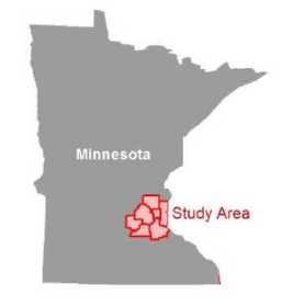
The three banks included Wells Fargo, US Bank, and TCF in the seven counties surrounding Twin Cities, MN. Since I am currently employed at US Bank I built the application from that company’s point of view, meaning “competitor locations” would be TCF and Wells Fargo locations. In order to run the analysis the user would need to click on a US Bank location. This is probably a good time to mention that this application and project was solely for academic purposes and all the data I used was publicly available.
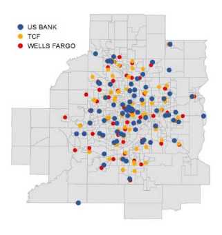 To create the bank location data, I utilized each bank’s website to create lists of all their locations within the Twin Cities seven county metro. After compiling all the bank locations into the spreadsheets, I geocoded all the addresses to create shapefiles that will be used throughout the project. I also utilized publicly available census tract data for the population statistics that will be shown in the mapping application. The map services were styled within a desktop GIS software and published to either ArcGIS for Server or GeoServer. Throughout the next three installments of this blog series I will discuss my experience building the ESRI system, my experience with the Open Source system, and then I will conclude with my final thoughts. I hope you enjoy the series and it helps you build your own web GIS!

Looking forward to hearing more about the experience!
Get all your Cornell buddies to buy my courses :-)
same here, same here ;)
I’ll be following this with great interest as well.
Pingback: The Web Duel – ESRI Implementation | gisadvising
Pingback: The Web Duel: part 3, Open Source | gisadvising
Pingback: The Web Duel – Last Thoughts | gisadvising